Daily Commercial News and Shipping List (Sydney) 14 May, 1912.
They had taken the specimens
produced in Court at this spot.
An awning spar and one of the
planks exhibited in Court had
also been discovered in close
proximity. Other articles were
picked up about 20 miles from
that spot.
The 'specimens' referred to were samples of the oily water discovered by Captain Upjohn of the Bullarra.
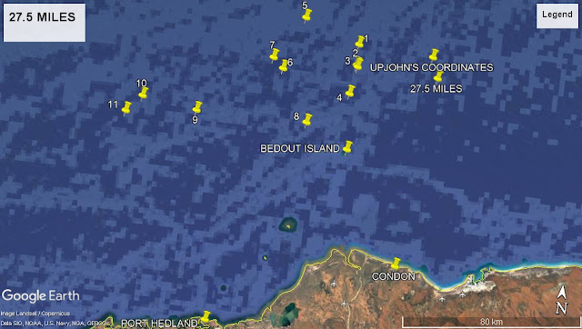
During the course of this blog I have expressed an opinion that the wreck of Koombana will be found where Captain Upjohn discovered the 'oil patch', the outline of which resembled a steamer. There is, however, a discrepancy between Captain Upjohn's given coordinates, 30 n miles NE of Bedout Island and his estimated distance of 27 to 28 n miles. The deviation error could in part be due to highly magnetic undersea iron ore bodies causing a compass variation of up to 55 degrees and a dip to 33 degrees (Lecky, 1920:30).
Earlier in the course of this blog I decided to plot all Koombana wreckage discoveries relative to the 'oil patch' discovery and an assumed westward trending prevailing current. The above report is highly relevant and describes wreckage not included in existing period data and which, critically, was discovered in close proximity to the 'oil patch'. No wreckage, officially, was discovered to the east of this longitude position.
This enhances rather than detracts from a comprehensive search for Koombana N.E. of Bedout Island. But such searches hinge on the accuracy of Captain Upjohn's estimation which draws our attention back to the Inquiry during which he had this to say:
"It was getting dark and it looked like the outline of a vessel (oil). The Chief Officer said "It must be one of her decks," I said "No, the decks would not look like that." I could see no more. The engines were stopped and we drifted for about 4 miles."
Captain Upjohn was convinced he had found the site of the wreck which prompted collecting 'two or three dozen bottles of the oily substance'. In order to calculate by dead reckoning an accurate position of the find it seems that he allowed Bullarra to drift for 4 miles which would have established three important factors in his calculation, set = current's direction, drift = current's speed and leeway = wind factor. All of these factors would have assisted in establishing Bullarra's true position. As it 'was getting dark' Captain Upjohn would have been assisted by identifying a specific rise star to further establish his position i.e. celestial navigation. This would have offset compass deviation.
I believe, in conclusion, that Captain Upjohn's 2 to 3 mile uncertainty is compensated by the lengths he went to to establish the position of his find and collect evidence in the form of oily water samples.
This is a no-brainer, it is time to find Koombana N.E. of Bedout Island!
1. Stateroom door; painting stage; small pieces of board. SS Gorgon
2. Motor launch starboard bow plank (with insignia). SS Bullarra
3. Small wreckage; (life) boat tanks; lifebelts; panel from saloon / smoke room ceiling. SS Bullarra
(see: https://koombanarevisited.blogspot.com/2019/11/sufficient-warning.html)
(see: https://koombanarevisited.blogspot.com/2019/11/sufficient-warning.html)
4. Bottom board from (life) boat; white painted board. Lugger McLennan.
5. (life) boat mast and small wreckage (rising from bottom). SS Una
6. Miscellaneous wreckage. SS Una
7. Miscellaneous wreckage. SS Una.
8. Cabin paneling. Lugger Mina.
9. Smoking room cushion; cabin door. SS Minderoo.
10. Straw envelopes (Leech's fortune). SS Minderoo and SS Gorgon.
(see: https://koombanarevisited.blogspot.com/2019/11/sufficient-warning.html)
(see: https://koombanarevisited.blogspot.com/2019/11/sufficient-warning.html)
11. Bottom boards (lifeboat); drawer; small teak panel. SS Minderoo.
courtesy Trove and Google Earth


No comments:
Post a Comment